OPCOST

OPCOST is a software for cost calculation of road users and for transport economic evaluation of road projects. Its databases are updated at least once a year.

USE OF THE SOFTWARE

The software is used as a tool for measuring price ratios between the investment in a road infrastructure project and user benefits as its consequence. With the calculation of economic indicators (net present value, internal rate of return) it enables classification of several road projects by investment costs and by change of direct user benefits because of the project implementation. In this way we can choose the most suitable option among several variants of the transportation project.

VALUATION BASIS

An investment project is preferred if discounted benefits exceed its discounted costs.

Benefits are defined in the software as the difference between user costs on existing infrastructure and after investments in the infrastructure has been made. In cost calculation, not only user costs are taken into account, but also traffic accidents and road maintenance costs.

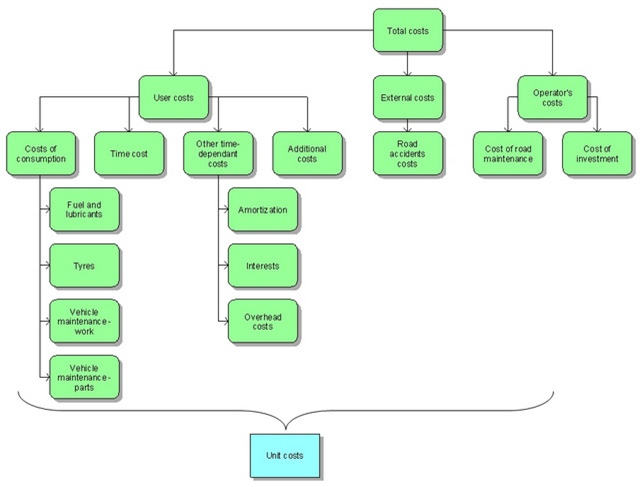
Figure 1: Costs includend in the software OPCOST

Individual costs per unit are an integral part of the software and are updated at least once a year. These costs are the basis for all subsequent calculations.

SOFTWARE STRUCTURE

The software consists of several parts. The most important parts are the calculation of costs and the transport economic evaluation of a project. In addition, the software also provides the use of various reports.

In the subprogram for cost calculation, total costs are calculated on the basis of technical and traffic characteristics of road sections in the impact area of investment (road network).

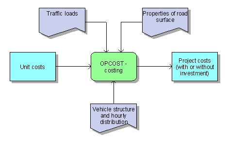
Figure 2: Input data for cost calculation

The subprogram for transport economic evaluation allows the calculation of economic indicators on the basis of calculated benefits (as the difference between costs with or without investment), investment costs and discount rates.

Figure 3: Transport economic evaluation of a project

Weather stations on Slovene roads

WINTER SERVICE

Winter road service is a number of activities necessary for winter road maintenance and for assuring normal road conditions and road safety in case of snow, glaze, frost etc.

INTELLIGENCE SYSTEM

The goal of the Slovene Roads Agency as the road management authority is to have an up-to-date, functional and efficient intelligence system providing real time information on weather and road conditions on specific road sections to interested end-users.

Weather data is split into two groups – data concerning air quality and data on road conditions due to the weather.

This information is useful for more efficient road maintenance with a higher quality of service and it is an important source of information also for other public services and interested public.

COMMUNICATION

OMEGA consult has placed 86 road and weather stations on chosen sections of the national road network and included them in the road and weather conditions intelligence system.

Collected data is transferred to end-users using modern information and communication technology.

Video surveillance

VIDEO SURVEILLANCE

Modern information technology enables the capture, transfer and communication of the relevant road, weather and traffic data in real time. Numerical data, combined with real time video provides a comprehensive surveillance and information system. OMEGA consult has placed over 100 video cameras on the national road network on behalf of the National Roads Agency, Sector for road infrastructure management and maintenance. Video surveillance system has been upgraded with weather tracking sensors in the last two years. The picture below shows the locations of currently placed video systems.

The real time video capture can be followed online on www.promet.si. It enables economic and current distribution of information to the public and is beneficial to all types of road users (automobile associations, radio stations, drivers, HGV drivers, road maintenance etc.)

Communication channels are crucial for an efficient and quick transfer of information.


Optical fibre communication cables would be the ideal transfer media for video signal but most of the national road network is not equipped with them. DSL connections also enable real time picture.

Alternatives like ISDN, GSM, and GRPS are used where optical fibres and ADSL aren't available, but due to lower band width for data transfer the video picture can in that case only be shown in 30 second intervals.

Central vehicle register

VEHICLE TYPE APPROVAL

The purpose of the conformity of vehicles is to put into use only such motor vehicles, trailing road vehicles, vehicle spare parts and accessories for these vehicles, which comply with the applicable regulations in the automotive area. The procedure is performed prior to placing the vehicle in use, ie prior to vehicle registration. The result of compliance with relevant regulation is the Certificate of Conformity of the vehicle, which is a prerequisite for its registration. The administrator of vehicle conformity data in this way controls a fleet of vehicles in the domestic market in terms of technical characteristics, the achievement of environmental standards, safety requirements, and the like.

INFORMATION SYSTEM SCHEME

The vehicle approval procedures are implemented by manufacturers or their authorized national representatives, the individual vehicle approval procedure CRV (i.e. single import, vehicle modification / tunning) is carried out by a designated professional organizations.

Vehicle type approval IS collects and verifies information on issued approval certificates sent in real time by certified vehicle sellers and certified vehicle type approval organizations. After processing it, the received information is sent to the vehicle registration authority.

CRV APPLICATION
A part of the information system is the Visual Basic application CRV, which enables users at the national vehicle type approval authority to input, organize and examine data concerning vehicle type approval and upon that issue documents (forms, technical data etc.).

VIPOS

What is VIPOS?

VIPOS is a tool for road data collection and processing developed by OMEGA consult. Raw data on road infrastructure are collected in motion by video detection with simultaneous GPS spatial positioning. By thus it is possible to create a database with exact location of road and road equipment.

With VIPOS there are no limitations for inclusion of any road element (bus stop, object, culvert, shoulders, bike lanes, drainage, pavement, fence, walls, special belts etc.).

Graphical data layer:

  • connects road attribute data to any GIS system,
  • shows the horizontal road alignment,
  • shows the vertical road alignment,
  • shows the 3-D road alignment model.

360 PhotoSphere

Drone footages serve for the preparation of digital ortophotos (DOF), digital elevation models (DEM) and other formats.