Research and development

In the registry of researchers´ managed by the Public Research Agency our company is listed under Nr. ARRS 1332. We currently employ 6 researchers.

We elaborate research studies regarding transport infrastructure, city public transport, information systems, communication and leadership techniques, transport technologies and economic planning.

Our research assignments from the last 5 years included:

DEVELOPMENT DOCUMENTS, INFORMATION SYSTEMS

  • feasibility studies, development studies and information system concepts for rail, road and cableway transport
  • national programmes for the development and maintenance of roads.

TRAFFIC SAFETY

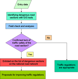
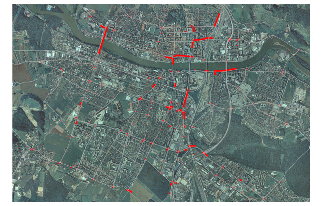
  • development of methodology for mapping dangerous road sections on the national road network,
  • traffic safety analysis of “black spots” with suggested action plans for better traffic arrangements,
  • development of methodology for tracking  traffic safety efficiency,
  • international study on road traffic safety for 9 EU countries.

TRAFFIC, MOBILITY, ENVIRONMENT AND SPACE

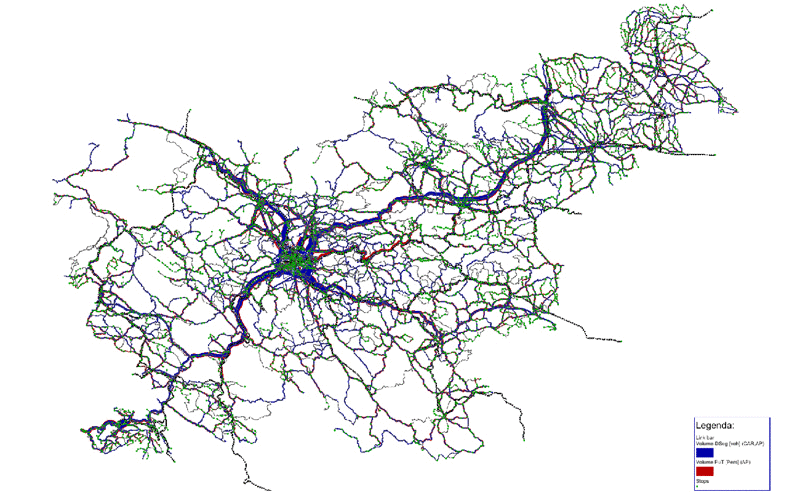
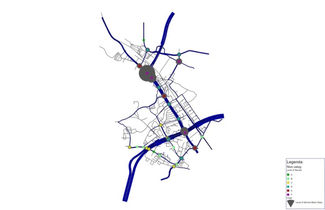
  • expert groundwork for integrated public transport management  in Ljubljana urban region,
  • strategy for the construction of cableway systems in Slovenia with spatial, environmental, transport and logistic guidelines,
  • expert groundwork for placing economic projects from Slovene regions in physical space, including economic structure, freight and transit traffic analysis,
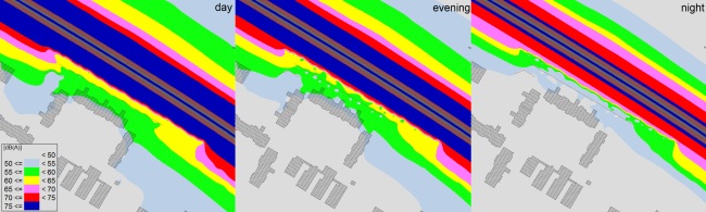
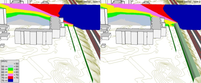
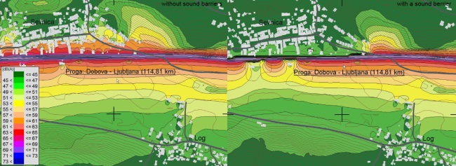
  • an estimate of increased noise and emission levels due to the outflow of heavy goods vehicles from the national roads to parallel roads.

LEGISLATION AND REGULATIONS

  • update of regular road and object maintenance norms and standards,
  • coordination with EU legislation,
  • expert groundwork for the tasks and duties of road management and maintenance as well as the socio-economic valuation of road projects.
  • particiation in the development of legislation concerning roads and cableways.

SOFTWARE AND INFORMATION SYSTEMS DEVELOPMENT

We have developed software programmes OPCOST and VIPOS. OPCOST is a tool for measuring the ratio between the investment in road infrastructure and user benefits that derive from the investment. It enables the classification and comparison of investment projects with regard to traffic and economic efficiency. VIPOS is a tool for road data collection and processing. Our other information tools are described under PRODUCTS.

DEVELOPMENT OF METHODOLOGIES, CRITERIA

  • methodology for the verification of “black spots” on road network,
  • methodology for evaluating national co-financing share in EU projects,
  • methodology for setting actions and splitting costs due to volume increase of freight vehicles on national roads,
  • methodology for setting necessary sanitation actions on congested infrastructure and the cost split between state road manager and users, who cause congestion,
  • criteria for defining distances between motorway access and exit points.
  • methodology for determining the necessary measures and cost sharing between public roads operators and watercourse managers.

Investment documentation

We are one of the first companies in Slovenia, which began elaborating investment documentation. In our 30-years of experience, we have collaborated with many different public and private clients and helped develop the methodology for the evaluation of public infrastructure investments. OMEGA consult has also developed the computer programme OPCOST that is now the official national tool for the calculation of economic viability of road infrastructure investments.

OMEGA consult elaborates all types of investment documents on behalf of investors.

Preparing the necessary investment documentation is a complex procedure on four levels:

  • studies and research that represent a basis for the viability of the project and for the elaboration of investment, project and spatial documentation,
  • elaboration of investment documentation,
  • elaboration of project documentation (project concept, design for construction permit etc.),
  • elaboration of spatial documentation (national spatial plan, detailed community spatial plan, construction permit etc.).

The documents are inter-related (existence of one document is conditional for the other one) therefore, the elaboration of investment documentation is a multistage project, which enables transparency and efficient control of the project.


Information systems

OMEGA consult is actively involved in integration and development of information systems. Examples of successful system integration are our products E-tolling and VIPOS (see PRODUCTS).

OMEGA consult has developed and is still developing and maintaining all information systems below:

  • software for monitoring vehicle compliance – type approval;
  • software for monitoring road infrastructure investments on state roads in Slovenia;
  • software for information of tachographs and vehicles ADR;
  • software for information of pressure vessels;
  • partial software e-Sport, application Youth Sports;
  • IT system concept for the ER in Ljubljana;
  • IT system concept for information of passengers in public transport in Ljubljana and Podgorica (Montenegro).

Furthermore, among the important solutions at OMEGA consult we consider the development of new platform for informing passengers in Slovenia about different modes of public transport. The portal supports the system EDaljinar for managing the public transport infrastructure and the National Timetable. The systems are connected with Google Transit and enable the door-to-door route planning with public transport in Slovenia and in the EU.

In order to integrate systems and optimize data compatibility and transfer we are exploring various technologies which are based on spatial data and GIS systems.

Our work can be divided into 2 areas: Integration of information systems and Development of information systems.

INTEGRATION OF INFORMATION SYSTEMS

As part of integration of information systems, we are researching all advanced technologies which appear in the world today. We are looking for synergies and possibilities to connect and transfer data between them. Our work is based on process management which we model with modern tools and in cooperation with our clients. Various statistical analyzes are prepared to support the results.

With focus on our clients’ wishes and needs, we are constantly seeking for feasible and financially sustainable solutions. In order to achieve them, we evaluate integrated systems which result from detailed cost-benefit analyzes.

DEVELOPMENT OF INFORMATION SYSTEMS

OMEGA consult is partner with ORACLE and has a number of licenses for working with development tools. We follow the latest IT trends to develop products with three-level architecture and internet solutions.

We always implement systematical and methodological approaches, so that the system design and development have methodological correct foundations.

The second key element of the development of information systems is in its perfect content. We ensure the latter is in accordance with right legislation and standards.

The system comes to life when it is successfully integrated in our clients’ environment. Therefore, tight collaboration with our client is a must. Our aim is to connect with our clients’ practice by taking into account his wishes already during the development stage. After integration, all systems are also regularly maintained.

Our company is partner with ORACLE, in addition we also hold many licenses to work with development tools.


Traffic safety

Traffic and especially road safety is becoming one of the most important research areas of our company. We are focusing on solutions for improving traffic safety by optimizing road infrastructure and conducting analyzes on local, national and international level. Analyzes are based on traffic safety indicators with the use of established statistical methods as well as self developed software and GIS programmes.

SPOTS WITH HIGH ACCIDENT RATE

We prepare a yearly overview of dangerous road locations on national roads that are managed by the Slovenian Roads Agency and DARS, the Slovenian Motorway Company. Dangerous road sections are those, on which at least one traffic accident with an injury has occurred in the last three years. They must also have an incidence of traffic accidents with injury that is higher than the critical value for similar road sections.

Definition of dangerous road sections is a multi step process.We determine them with the help of statistical traffic accidents database (traffic monitoring and count, road network and traffic accidents) and on the basis of recommendations from European Union for establishing a system for managing dangerous road sections. We identify separately dangerous road sections and intersections. Over the years, this methodology has been upgraded several times in order to obtain optimal results according to available date.

The locations where accidents occur frequently are furthermore examined on the field. During our visit of specific location, we examine the traffic regulation and the road alignment (subsection or intersection). We also arrange a meeting with the local police officer and prepare image and video material for further analysis.


Following the analysis,we suggest for each and every location various measures which would improve traffic safety. Measures can be short - term (or low-cost, as they can be effective for a longer period of time, regardless of their costs) or long-term. If further analysis are required, special studies are made.

Dangerous road sections 'black spots' in Slovenia 2014 - 2016 analysis:
Between 2014-2016, 110 sites with high accident frequency were recorded (in two steps), out of which 26 were road sections and 84 crossroads. We have carried out 24 meetings with the local representatives of the police, at 24 different police stations. In total, 32 sites with high accident frequency were examined in detail. At some police stations, the accidents were not thoroughly inspected, therefore only a general opinion of the accident location was provided. We proposed for each location various measures which would improve safety concerns (some of them already implemented some of them suggested additionally while some of them are due to unregulated road infrastructure). The remaining dangerous road sections, where a field visit and meeting at the local police station wasn’t carried out, were also thoroughly analyzed. These are mostly repetitive dangerous road sections, which we have already dealt with in the past and for some of them already made a study of conceptual solutions. We have analyzed them again in order to inform the Directorate of the Republic of Slovenia for Infrastructure that the same sites, from the past analysis, still appear as dangerous in new results. As part of the task, it was found out that in 2016 and 2017 a comprehensive approach was taken to implement measures to improve road safety. Measures to improve road safety have been implemented in the vast majority of “black spots”. A number of measures will be implemented in 2018 as well. We estimate that the vast majority of “black spots” will extinguish in the upcoming years (due to the three-year period of our studies, a dangerous road section can appear as such for another 2 years after measures are implemented).

Identified "black spots" on the national road network for 2014-2016 - Step 1 (52 black spots)

Identified "black spots" on the national road network for 2014-2016 - Step 2 (58 black spots)

APPLICATION »TRAFFIC SAFETY ANALYSIS«

We develop annually the "Traffic Safety Analysis" application which enables users to produce reports with a traffic safety analysis for the selected section or municipality with its overview based on traffic accidents data for the period 2004-2016 in PDF format. The user can select among the section, road section part, the municipality, the period of analysis, and the cause of the accident.

The traffic safety is presented in the selected section, municipality or cause of the accident in different ways, namely:

  • number of accidents and their consequences per year;
  • costs of road accidents per year (level 2016);
  • development of road accidents since 2004;
  • number of accidents and their consequences;
  • number of traffic accidents per road section;
  • number and type of participating vehicles;
  • number of traffic accidents per type and cause;
  • number of road accidents per road surface and the condition of the road at the time of the accident;
  • number of traffic accidents according to the state of traffic and the state of the weather at the time of the accident;
  • number of traffic accidents per hourly interval of the day;
  • number of participants per road accidents successively;
  • number of participating vehicles successively.


Environment


OMEGA consult is active also on the field of environment. We elaborate environmental impact assessments, monitor and measure environmental factors on local, national and international level when evaluating economic viability of investment projects.

MODELLING NOISE AND POLLUTANT EMISSIONS

The predominant source of noise in the wider natural and urban environment is the noise from road, rail and aviation infrastructure and noise from industrial facilities.

Environmental legislation defines permissible limits and critical environmental noise levels. The environmental impact of noise is measured with noise indicators and expressed in dB(A). Noise indicators are classified according to the time of day (day, evening, night and all day noise). Noise generated by transport infrastructure or an operating industrial facility is modelled with the software SOUNDPLAN. The software uses a 3-D model of terrain and objects surrounding the observed area to create noise emission maps for different parts of day.

1. Modeling noise emissions of road and rail traffic and industrial facilities

Process optimization of sound barriers:

Noise emissions from road traffic with different types of sound barriers:

Noise emissions of rail traffic with or without sound barriers:

Noise emissions from an industrial facility:

2. Modelling pollutant emissions of road traffic

Emissions of CO2 and PM10 pollutants along traffic routes

EXTERNAL ENVIRONMENTAL COSTS

Considering the EU guidelines, we are trying to include as many external costs into the economic viability evaluations of infrastructure investment projects as possible. Environmental costs are a large part of the total external costs that society bares due to traffic.  These are mostly air pollutants´ (e.g. NOx, HOS, SO2, PM2,5, PM10,CO2, N2O, CH4) emission costs, which are difficult to determine. For their assessment we are using programmes HBEFA 3.1, VISUM and SOUNDPLAN that calculate the quantities of dispersed particles in certain areas. Multiplication of these quantities with value assessments gives us an estimate of the external costs of air pollution.

Economics of transport

EVALUATION OF COSTS AND BENEFITS

Costs of participants in traffic are calculated on the basis of traffic forecast or field research.

The following tools are used for the economic evaluation road users’ benefits:

  • OPCOST, software developed by OMEGA consult Ltd.
  • TUBA, software developed by the University of East Anglia, UK
  • HDM 4, developed by Data Collection Ltd., New Zealand.

Calculated costs contain costs of time as well as consumption and wear and tear costs for all types of personal and freight traffic. Based on users´ costs in the analyzed period we calculate their benefits and traffic efficiency of individual projects or project variants.

COST AND BENEFIT ANALYSIS

Due to high costs of building and environmental impacts all infrastructural influences must be evaluated on the long term. Investors´ available assets are limited; therefore, it is important to choose the most important and economically viable investments.

An analysis of costs and benefits includes:

  • calculation of economic viability of projects based on users´ benefits and costs of investment,
  • comparisons of different investment scenarios,
  • CBA analysis including direct and indirect cost of investment,
  • optimal order of specific building stages.

ROAD MANAGEMENT

The basic function of road management is the maintenance and improvement of current road network status in order to ensure usability, efficiency and safety of traffic.

Given the envisaged usage of the road we can expect that it will safely and satisfactorily serve its purpose in the expected lifetime. The speed of road degradation is conditioned by the traffic loads, climatic, geological & hydrological characteristics of air and ground.

Road management programme – PMS (Pavement Management System) stands for efficient and reasonable management of all those activities that contribute to keeping the roads in good condition at minimal cost in the planned period. These activities include planning, dimensioning, building, maintenance, research and monitoring. PMS sets priority maintenance and development tasks, assesses their necessary funding and realization dynamics in the planned period.

A road management plan includes:

  • set of necessary road restoration activities and their priority order,
  • socio-economic and multi-criteria evaluation of project variants,
  • assessment of funding,
  • model of dynamics,
  • expected effects.

Traffic

TRAFFIC MODELLING AND SIMULATION

TRAFFIC MODELLING ON MACROSCOPIC LEVEL

Macroscopic traffic models (strategic models) are made on larger areas (regionally or nationally). Macroscopic models are usually multilevel: modelling of generations and attractions, trip distributions, choice of transport modality and traffic loads and they include personal, public and all types of freight transport.

Macroscopic model results are vehicle flow estimates on the road network, their speed and concentrations on hourly or daily basis.

prometno-01

TRAFFIC MODELLING ON MEZOSCOPIC LEVEL

Mezoscopic traffic models are usually used for urban areas. Their level of accuracy is between macroscopic and microscopic models. They do not include demand modelling; only traffic loads. They describe the road network more in detail and include attributes of crossroads, junctions and road splits. Results of this model are the detailed vehicle flows and speeds on the network estimates like the number vehicles turning left, speeds and delays in crossroads and their dynamics.

prometno-2

MICROSCOPIC TRAFFIC SIMULATION

Microscopic traffic models enable the most detailed insight into traffic flows on existing and future transport infrastructure. Same as mezoscopic models, they too include only traffic loads for each specific vehicle. Next to classic vehicle modelling this model can also be used for modelling pedestrians in various situations. Physical attributes of transport network are set in detail, which makes it possible to consider traffic from all points of view (cars, trucks, buses, rail, cyclists, pedestrians and traffic signalisation).

The result is a visual traffic simulation with a number of information on network operation (speed, travel times, delays, traffic jams, bottlenecks, number of stops and the dynamics in the crossroads, traffic lights cycles etc.)

prometno-3

TRAFFIC STUDIES

A reliable transport study is the basis for quality planning, dimensioning and designing of transport infrastructure.  Therefore, transport studies analyze, plan, suggest and project various types of traffic solutions for road, rail, bicycle, pedestrian and stationary traffic.


prometno-4

CROSSROADS DESIGN

New construction: Basis for new crossroad design is a traffic study with a 20-year traffic flow forecast upon which an optimal crossroad type is determined (crossings with or without traffic lights, roundabouts…) and its dimensions (lane width, number, length…).

Reconstruction: is made based on traffic counts and a 20-year traffic flow forecast upon which an optimal type and dimension of the crossroad is determined.

World renowned aaSIDRA Intersection software for independent crossroad design as well as VISSIM are used for the process.

prometno-5

FIELD RESEARCH AND MEASUREMENTS

For the needs of studies and research we conduct:

  • traffic counts;
  • tracking and surveys on the roads, parking lots, on means of public transport and by households;
  • measurements of travel time;
  • measurements of speed;
  • measurements of traffic densities;
  • video counts.

Mobility

We elaborate wholesome traffic system arrangements of urban environments, regions and inter-regional traffic connections. We also plan and design business and logistics centers and place them in physical space.

Good accessibility to key services along with minimum negative impacts of motorized traffic on society and environment as well as interaction with spatial and socio-economic factors are main guidelines when planning and arranging traffic systems.

INTER-REGIONAL TRAFFIC CONNECTIONS

When planning a new long distance transport link that will bring many development synergies to the area, the new transport corridor is chosen based on minimum measured impacts on the environment, people, economy and space.

TRAFFIC SYSTEM ARRANGEMENTS OF URBAN ENVIRONMENTS

Integrated traffic system arrangements of urban environments include:

  • planning of traffic network,
  • designing stationary traffic and parking policy,
  • traffic town center planning.

Suggested policies and traffic planning measures consider existing urban design plans and future development plans.

PUBLIC PASSENGER TRANSPORT (PPT)

We plan and design PPT for cities and wider city regions in order to achieve a PPT network that is designed to fit the demand and needs of passengers. This includes:

  • plan of lines,
  • plan of stops and park & ride stops,
  • multimodal transport terminals,
  • organisational structure for managing the PPT,
  • tariff and payment system and
  • integration of various transport modalities.

BUSINESS AND LOGISTICS CENTRES

By designing and planning business and logistics centers with traffic and spatial organization and arrangements we contribute to the development of competitiveness of local and national business environment.